Japan is easier to understand when you picture it as a long island chain first, then add its regions, and finally zoom in to its 47 prefectures. The country stretches in a gentle arc off the eastern side of Asia, with snowy northern landscapes, broad urban plains, inland mountains, warm southern islands, and many smaller coastal communities. Once those layers are clear, Japan’s map feels less like a puzzle and more like a well-organized set of rooms in one house.
A Simple Way to Picture Japan
Think of Japan in three layers:
- Islands explain the physical shape of the country.
- Regions help people talk about broad areas such as Hokkaido, Kanto, Kansai and Kyushu.
- Prefectures are the local units you see in addresses, travel pages, weather reports and regional data.
That is the cleanest starting point. Island shape, regional label, prefectural identity. Keep those three ideas in mind and the rest becomes much easier.
Japan’s Main Numbers
Before looking at every region, it helps to place Japan on the map with a few reliable basics. The figures below are rounded for readability, except where the official count is already simple.
47
Prefectures
Japan is divided into 47 prefectures, including Tokyo, Hokkaido, Osaka and Kyoto.
377,976 km²
Surface Area
Official land tables list Japan’s surface area at about 378 thousand square kilometers.
About 124 million
Population
The national population is just under 124 million in recent official estimates.
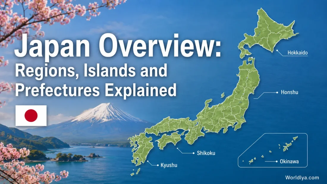
Is Japan One Island or Many Islands?
Japan is not one island. It is an archipelago, meaning a chain or group of islands. The land runs roughly northeast to southwest, with the Pacific Ocean on one side and the Sea of Japan on the other. This long shape is why the country can feel very different from north to south.
Most people first learn the four large islands: Hokkaido, Honshu, Shikoku and Kyushu. Many official summaries also name Okinawa as a main island area because it anchors the southern island chain. Around these are more than 14,000 smaller islands of different sizes.
Plain-English map idea: Honshu is the long central spine. Hokkaido sits to the north. Kyushu lies to the southwest. Shikoku rests between Honshu and Kyushu. Okinawa and the Ryukyu Islands stretch farther south like stepping stones across warm waters.
The Main Islands and What They Help Explain
| Island or Island Area | Approximate Area in Official Land Tables | What It Helps You Understand |
|---|---|---|
| Honshu | 231,240 km² | The central and largest island, home to Tokyo, Kyoto, Osaka, Nagoya and many of Japan’s most visited inland and coastal routes. |
| Hokkaido | 83,422 km² | The northern island, known for wide landscapes, cold winters, national parks, farming areas and Sapporo. |
| Kyushu | 42,230 km² | The southwestern large island, with coastal cities, warm areas, mountain scenery and strong local food traditions. |
| Shikoku | 18,802 km² | The smallest of the four large islands, often linked with pilgrimage routes, rural landscapes and the Seto Inland Sea. |
| Okinawa | 2,282 km² | The southern island area, part of a subtropical island chain with coral seas, distinct local culture and warm weather. |
The numbers make one thing clear: Honshu dominates the map by size and population, but the other islands add much of the variety readers notice when comparing climates, landscapes and local identity.
Regions: The Map Labels People Use
Japan’s regions are broad labels used to make the country easier to discuss. They are not the same as prefectures. A region can contain one prefecture, several prefectures, or an island group. You will see these names in travel planning, school materials, cultural pages, weather summaries and general country guides.
The eight common regions are Hokkaido, Tohoku, Kanto, Chubu, Kansai or Kinki, Chugoku, Shikoku and Kyushu-Okinawa. Some sources separate Okinawa from Kyushu in certain contexts, while many overview maps combine them as one southern region.
Why two names: Kansai and Kinki? Both names are used for the region around Osaka, Kyoto, Nara and nearby prefectures. Kansai is very common in tourism and everyday English. Kinki appears in formal or regional naming. For a general reader, treating them as the same broad area is usually enough.
Prefectures: The 47 Local Units
Prefectures are the local units most readers need for practical understanding. They appear in addresses, tourism boards, local statistics, transport maps and regional profiles. Japan has 47 prefectures, but the names do not all end in the same suffix.
- Tokyo-to is usually translated as Tokyo Metropolis.
- Hokkaido uses the do form and is both a region and a prefectural-level unit.
- Kyoto-fu and Osaka-fu are urban prefectures.
- The other 43 are commonly written with ken, often translated simply as prefecture.
For visitors and readers, the suffix is less important than the location. Tokyo, Kanagawa, Osaka, Kyoto, Hokkaido, Fukuoka and Okinawa are all prefectural names, even though they may also be linked with cities, regions or islands in everyday language.
All 47 Prefectures by Region
This table is the most useful part to keep nearby. It shows how Japan’s prefectures are usually grouped in a regional overview.
| Region | Prefectures | Reader Note |
|---|---|---|
| Hokkaido | Hokkaido | One region, one prefectural-level area, one large northern island. |
| Tohoku | Aomori, Iwate, Miyagi, Akita, Yamagata, Fukushima | Northern Honshu, with Sendai as a major urban center. |
| Kanto | Ibaraki, Tochigi, Gunma, Saitama, Chiba, Tokyo, Kanagawa | The broad Tokyo-area region and one of the easiest regions to spot on population maps. |
| Chubu | Niigata, Toyama, Ishikawa, Fukui, Yamanashi, Nagano, Gifu, Shizuoka, Aichi | Central Honshu, crossing mountain, inland and coastal areas. |
| Kansai or Kinki | Mie, Shiga, Kyoto, Osaka, Hyogo, Nara, Wakayama | The region around Osaka, Kyoto and Nara, often called Kansai in everyday English. |
| Chugoku | Tottori, Shimane, Okayama, Hiroshima, Yamaguchi | Western Honshu, facing both the Sea of Japan side and the Seto Inland Sea side. |
| Shikoku | Tokushima, Kagawa, Ehime, Kochi | A compact four-prefecture island region south of western Honshu. |
| Kyushu-Okinawa | Fukuoka, Saga, Nagasaki, Kumamoto, Oita, Miyazaki, Kagoshima, Okinawa | Southwestern Japan, usually including Kyushu and the Okinawa island chain in broad regional maps. |
How Regions, Islands and Prefectures Fit Together
A common mistake is to treat islands, regions and prefectures as if they were the same kind of thing. They overlap, but they answer different questions.
| Question | Best Term to Use | Example |
|---|---|---|
| What landmass is it on? | Island | Tokyo is on Honshu. |
| What broad area does it belong to? | Region | Tokyo is in Kanto. |
| What local unit is named in addresses and data? | Prefecture | Tokyo is a prefectural-level unit. |
| What city do most people mean in daily speech? | City or Urban Area | Tokyo can refer to the central urban area in casual speech. |
So when someone says “Tokyo is in Japan”, that is true but broad. A sharper map sentence would be: Tokyo is a prefectural-level area in the Kanto region on Honshu.
Region-by-Region Notes for a Clearer Map
Hokkaido: The Northern Island Region
Hokkaido is simple to remember because the island, region and prefectural-level area share the same name. It is the northernmost large island and has a much colder seasonal feel than southern Japan. Sapporo is the best-known city, and the region is often linked with open landscapes, winter activities, farming and national parks.
Tohoku: Northern Honshu
Tohoku sits on the northern part of Honshu. It includes six prefectures and often feels more spacious than the busiest urban regions. Readers will often see Tohoku in pages about seasonal scenery, local festivals, mountain areas and coastal travel.
Kanto: Tokyo and Its Neighboring Prefectures
Kanto is the region most foreign readers meet first because it includes Tokyo, Kanagawa, Chiba and Saitama. It is also where many maps place the country’s largest urban concentration. When a weather report, train page or event listing says “Kanto,” it usually points to the broader Tokyo-side area rather than Tokyo alone.
Chubu: Central Honshu
Chubu means the central part. It includes coastal prefectures, mountain prefectures and the area around Nagoya. It is one of the most varied regions on a map because it reaches from the Sea of Japan side across inland highlands toward the Pacific side.
Kansai or Kinki: The Osaka-Kyoto-Nara Area
Kansai is often the easier name for general readers. It includes Osaka, Kyoto, Nara, Hyogo and nearby prefectures. This region is compact on the map but full of famous place names, so it is worth learning early.
Chugoku: Western Honshu
Chugoku is the western end of Honshu. It should not be confused with China, even though the English spelling can create that first-second pause for new readers. In a Japan map context, Chugoku is a region made of five prefectures: Tottori, Shimane, Okayama, Hiroshima and Yamaguchi.
Shikoku: Four Prefectures on One Smaller Island
Shikoku is easy to read once you notice its name and layout. It has four prefectures: Tokushima, Kagawa, Ehime and Kochi. It sits south of western Honshu and near Kyushu, with bridges and ferry routes connecting it to nearby areas.
Kyushu-Okinawa: The Southwestern Region
Kyushu is one of Japan’s four large islands. The wider regional label often includes Okinawa as well, especially in broad country overviews. Fukuoka is a major city in northern Kyushu, while Okinawa lies farther south in an island chain with a subtropical feel.
Small Island Groups Readers Often Notice
Japan’s smaller islands are not just dots around the main islands. Some are close to major cities. Others sit far out in the ocean. For a general country overview, these island groups are useful to recognize:
- Ryukyu Islands: A long chain in the south that includes Okinawa and nearby island groups.
- Izu Islands: Islands south of Tokyo that are administratively linked with Tokyo.
- Seto Inland Sea Islands: Islands between Honshu, Shikoku and Kyushu, often seen in travel and art-route contexts.
- Amami Islands: Islands between Kyushu and Okinawa, linked with Kagoshima Prefecture.
These island groups show why Japan’s geography is not only about the four largest islands. The smaller islands give the country extra layers of climate, culture, transport needs and local identity.
Common Mix-Ups About Japan’s Geography
Is Tokyo a City or a Prefecture?
In everyday speech, Tokyo often means the city-like urban area people visit. In administrative terms, Tokyo is a prefectural-level metropolis. That is why you may see Tokyo listed beside prefectures such as Kanagawa, Osaka and Hokkaido.
Is Hokkaido a Region, Island or Prefecture?
Hokkaido can be all three in a general overview. It is a large island, it is one of Japan’s main regions, and it is treated as a prefectural-level local unit.
Are Kansai and Kinki Different Places?
They usually refer to the same broad region around Osaka, Kyoto, Nara and nearby prefectures. Kansai is the name most readers will see in tourism and daily English. Kinki appears in formal regional names and some institutional contexts.
Is Okinawa Part of Kyushu?
Okinawa is its own prefecture and island area. In broad regional maps, it is often grouped with Kyushu as Kyushu-Okinawa. In more detailed pages, it may be shown separately because its island chain and climate are distinct.
A Practical Reading Path
When you meet a Japanese place name for the first time, read it in this order:
- Find the island: Is it on Honshu, Hokkaido, Kyushu, Shikoku or Okinawa?
- Find the region: Is it in Kanto, Kansai, Tohoku, Chubu, Chugoku, Shikoku, Hokkaido or Kyushu-Okinawa?
- Find the prefecture: This gives the most useful local label for data, addresses and travel planning.
- Find the city or town: This is usually the name you need for hotels, stations, museums, weather and local routes.
For example, Kyoto is a city in Kyoto Prefecture, inside the Kansai region, on Honshu. Fukuoka is a city in Fukuoka Prefecture, in the Kyushu-Okinawa regional grouping, on Kyushu. Sapporo is a city in Hokkaido, where the island, region and prefectural-level area share the same name.
Why This Structure Matters for Readers
Japan’s geography affects how people describe food, climate, transport, travel routes and local identity. A noodle dish may be tied to one prefecture. A snow festival may be linked with one city in Hokkaido. A rail pass may cover one region, not the whole country. A weather note may mention the Pacific side or the Sea of Japan side rather than a single city.
That is why learning the map layers is not just a school exercise. It helps readers understand what they are seeing when they compare destinations, read local names, or follow a route across the country.
FAQ
How Many Prefectures Does Japan Have?
Japan has 47 prefectures. They are usually grouped into eight broad regions for easier reading and planning.
What Are Japan’s Four Main Islands?
The four large islands are Hokkaido, Honshu, Shikoku and Kyushu. Official summaries may also name Okinawa as a main island area because it anchors the southern island chain.
Which Region Is Tokyo In?
Tokyo is in the Kanto region. It is also a prefectural-level metropolis and the best-known urban area in Japan.
Which Region Is Kyoto In?
Kyoto is in the Kansai region, also known as Kinki. Kyoto is both a city name and a prefecture name, so context matters.
Which Island Is Osaka On?
Osaka is on Honshu, in the Kansai region. Osaka is also one of Japan’s two urban prefectures using the fu form.
Sources
- Statistics Bureau of Japan — Statistical Handbook of Japan
- Statistics Bureau of Japan — Current Population Estimates as of October 1, 2024
- e-Stat Japan — Prefectural Data
- Web Japan — Regions of Japan
- Study in Japan — Life in Japan by Specific Areas
- Geospatial Information Authority of Japan — Maps and Geospatial Information